Options
Pulling my hair out over search site
I've been researching a site I want to detect that's very near my house. Here's a piece of a historical sketch written about the area (I'm leaving out specific names for a few reasons):
"About 1891 a recreational center was built across from what is now ------- -------- and on the opposite side of the river. This was known as the "Coney Island of --- ----- -------" and had been built by the W-------- and B--------- Street Railway Company, headed by ------- ------. An iron bridge was built across the river and the amusement park itself was built in a grove of trees, making a natural ampitheater. The hillside was terraced and seats were placed there, and then in 1895 a pavilion fifty feet by a hundred was built. The --- --- ----- football team [local semi-pro team, still in existance today] played there until it moved its games to the fairgrounds. Caves under the park also were a big attraction, with floors being built into them as well as stairs and electric lights strung. Traveling shows stopped there and the ---------- city band played there. A cable was strung over the river and a tightrope artist performed his act over the running waters. Also a total of thirty marriages were performed in the caves over the years."
This park only existed for 10 or 15 years. And, from what I can find, the land was then abandoned and sold to the local hydro plant company, which owns it today.
Here's the thing--I've found the abutment (spelling?) where the iron bridge attached to the amusement park side of the river, and have searched the immediate surrounding area, but can find nothing. The only evidence of humans over there is a modern power line running parallel to the river, with the path it takes mown down.
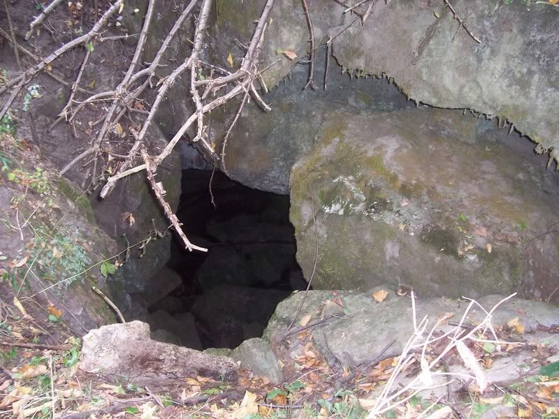
I have found cave entrances over there, but no sign of flooring, stairs or electric lights. Here's a pic of one of the larger entrances (the pic is deceiving--the entrance is about 15 feet high by 10 feet across):
I've hiked quite a bit of the area, which varies from the mown section, to thick brush, and then to 'old growth' woods. I keep looking for a terraced hillside, but really cannot be sure if I've found one (every cow/deer path makes me think of a row of 19th century bleachers!)
I've swung my Ace 250 a lot over there, but I've only found things in 2 places. Near the spot where the bridge hits the land, I found (very near each other) three old bullet shells. As a shooter/collector, I know that these are old shells, that although in use a bit today, have probably sat there for 70+ years. They were a .32 rimfire, .22 short and a .38 S&W (the precursor to the .38 special round). I have visions of a carnival shooting gallery--especially from finding the .22 short.
In the other spot, which could actually be at the foot of the 'natural ampitheater' (based on the layout of the land, but only a guess) I found another .32 rimfire and a stirrup. The stirrup is like one that and English saddle or perhaps a military cavalry saddle would have had. Here's a pic:

The thing that gets me is, based on many historical accounts, I've found a spot where perhaps hundreds of people at a time have congregated every year for 10-15 years straight at the turn of the century, and I'm getting virtually NO hits on the MD! Even if the area had been hunted before--even extensively--I should have SOME luck, don't you think?
All I can think of is Barber dimes and Morgan dollars when I'm over there! Very eerie place though--very quiet, and when you come across one of the cave openings, it sends a chill down your spine.
"About 1891 a recreational center was built across from what is now ------- -------- and on the opposite side of the river. This was known as the "Coney Island of --- ----- -------" and had been built by the W-------- and B--------- Street Railway Company, headed by ------- ------. An iron bridge was built across the river and the amusement park itself was built in a grove of trees, making a natural ampitheater. The hillside was terraced and seats were placed there, and then in 1895 a pavilion fifty feet by a hundred was built. The --- --- ----- football team [local semi-pro team, still in existance today] played there until it moved its games to the fairgrounds. Caves under the park also were a big attraction, with floors being built into them as well as stairs and electric lights strung. Traveling shows stopped there and the ---------- city band played there. A cable was strung over the river and a tightrope artist performed his act over the running waters. Also a total of thirty marriages were performed in the caves over the years."
This park only existed for 10 or 15 years. And, from what I can find, the land was then abandoned and sold to the local hydro plant company, which owns it today.
Here's the thing--I've found the abutment (spelling?) where the iron bridge attached to the amusement park side of the river, and have searched the immediate surrounding area, but can find nothing. The only evidence of humans over there is a modern power line running parallel to the river, with the path it takes mown down.
I have found cave entrances over there, but no sign of flooring, stairs or electric lights. Here's a pic of one of the larger entrances (the pic is deceiving--the entrance is about 15 feet high by 10 feet across):
I've hiked quite a bit of the area, which varies from the mown section, to thick brush, and then to 'old growth' woods. I keep looking for a terraced hillside, but really cannot be sure if I've found one (every cow/deer path makes me think of a row of 19th century bleachers!)
I've swung my Ace 250 a lot over there, but I've only found things in 2 places. Near the spot where the bridge hits the land, I found (very near each other) three old bullet shells. As a shooter/collector, I know that these are old shells, that although in use a bit today, have probably sat there for 70+ years. They were a .32 rimfire, .22 short and a .38 S&W (the precursor to the .38 special round). I have visions of a carnival shooting gallery--especially from finding the .22 short.
In the other spot, which could actually be at the foot of the 'natural ampitheater' (based on the layout of the land, but only a guess) I found another .32 rimfire and a stirrup. The stirrup is like one that and English saddle or perhaps a military cavalry saddle would have had. Here's a pic:
The thing that gets me is, based on many historical accounts, I've found a spot where perhaps hundreds of people at a time have congregated every year for 10-15 years straight at the turn of the century, and I'm getting virtually NO hits on the MD! Even if the area had been hunted before--even extensively--I should have SOME luck, don't you think?
All I can think of is Barber dimes and Morgan dollars when I'm over there! Very eerie place though--very quiet, and when you come across one of the cave openings, it sends a chill down your spine.
Need to finish my Kennedys and Jeffersons!
0
Comments
you are doing and when you will return. If you are late, they should send out the search
parties.
And do as much research as possible first.
-------------------------
Good trades with: DaveN, Tydye, IStillLikeZARCoins, Fjord, Louie, BRdude
Good buys from: LordMarcovan, Aethelred, Ajaan, PrivateCoinCollector, LindeDad, Peaceman, Spoon, DrJules, jjrrww
Good sale to: Nicholasz219
Cool finds, that stirrup and those old cartridges. You're definitely finding 19th century stuff. It'll be interesting to see if any coins turn up.
I wonder what the possibilities of finding a cache would be. Perhaps better in a cave- it seems a natural sort of place to hide stuff.
That picture of the cave entrance is interesting, and a little spooky!
Collector since 1976. On the CU forums here since 2001.
I'm going to hit the local library today--even one pic of the park taken from the opposite side of the river should give me enough info to direct me to a good spot to search.
Try turning disc. down some and look for heavy concentrations of iron and old trash. Make a map(mental or physical) and connect the dots.
A book about the local history had about 5 pages on the park. Here are a few snippets:
"...From this point, [where the trolleys let people off on the opposite side of the river] picnickers could cross the 300 foot span [of the bridge] into a grove of maples, about 250 in number, under which were provided picnic tables." (Note: there are no longer any of the maples where the bridge would have hit the land.)
"Along the river there were many concessions. Sam Ray sold popcorn and peanuts, while there was a Strobeck's Ice Cream and S.R. Ryan's Soda Water."
"Large throngs of people would visit the park on weekends. As many as five streetcars [trolleys] would be seen lined up at the siding across the river form the park."
"At the turn of the century, the football team was often playing before crowds of 4,000[!] enthusiastic spectators in [the park]."
"In 1904, the traction [streetcar] company sold the park lands to C. S. who needed it for pasturing his cattle."
"With the park lands reverting to pasture, time has made it difficult to envision thousands of football fans seated on the green slopes where now cattle graze."
This is driving me crazy! I should be tripping over signs of the park when I hike the lands! I'm just going to have to do some more searching over there. If I can convince one of my friends to come along, I just might check out the caves too. In my research, there are writings about only one large cave entrance, and I'm pretty sure it's the one that I pictured above.
I've been speaking to the property 'owners', seeking both information and official permission to access the area.
I was told by one person that he felt that the football field was in the opposite direction that I was searching, which could indeed be possible, but I haven't done much investigation.
A couple others have implied that some of the park was probably covered--part by industrial development (further back from the river than I had thought the park should be) and from work done by the local power authority when the hydro plant was built.
Both of these are plausible scenarios, but there is so much untouched land (based on the lay of the land and evidence of old pasture/fencing) that is still close to where the old bridge was that there must be something there. This is where I'm going to focus my md-ing.
My current focus, though, is on the cave. Through research, I know now that I have found the correct cave entrance, and that the reports of how it was used have been exaggerated over time.
A friend and I made one quick trip into the cave, but we weren't prepared as well as we should have been, and at the time I had doubts that it may not be the right entrance. We are headed back in this week. This time, though, I won't be trying to carry the detector, and I won't weigh myself down with 'what-if' gear that I probably won't need.
Tomorrow I plan on quickly md-ing the entrance to the cave (a room about 10-15 feet that shows old holes drilled in the stones and where square nails litter the floor.)
I know that this doesn't necessarily fit in with the "Metal Detecting" theme, but if anyone is interested, I will be glad to report back after my cave trip. I also hope to take a lot of pictures.
It fits my idea of "treasure hunting"!!! Metal detector is just a tool ;-)
Jerry
Good detective work--a couple others have found it as well. I guess now that I have received permission to access the area, it doesn't need to be so 'secret'.
<< <i>If you'll PM me the location of the area you're looking in (city, state, and rough lat/long), as well as any info you think is useful, I'll see if I can pull up any aerial photographs or some such that might help you get the lay of the land. You just need to give me enough information to locate the rough area on a map. I'm a M.S. student working with GIS software (a powerful mapping package) and I might be able to locate something you can use. I'm not making any promises, as I'm still learning the software, but I'll give it a go sometime this week if you get back with me. Sometimes, a good aerial photo can reveal old land features not visible from the ground any more. (Don't worry, I'm not interested in "scooping" you there!) >>
What platform are you using?